Making agriculture possible at the California and Arizona border: The All-American and Yuma Canals
Colorado River Basin from the lens of the U.S.-Mexico Border (Pt.3)
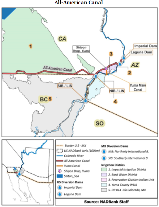
Water from the Colorado River has been key for the development of the agriculture sector along the U.S.-Mexico border in Imperial Valley (CA), Yuma (AZ) and the Mexicali Valley (in Mexico). To make the development of these hubs possible in the U.S., major water infrastructure projects were developed at different points in time. The Boulder Canyon Project produced the All-American canal bringing water to Imperial Valley and other parts of the California border, and the Yuma Project that led to the development of parts of Yuma, Arizona, specifically the Valley Division.
These two infrastructure projects translated into neighboring agricultural hubs that function separately and have different effects on the quality of the river water. In this post, we will present the four irrigation districts on the U.S. side of the border, how water is conveyed from the Imperial Dam, a diversion dam, to these farmlands by the All-American and Yuma Canals and the links to Mexican agriculture at the border.
Agricultural Hub 1: Imperial Valley Irrigation District on California border
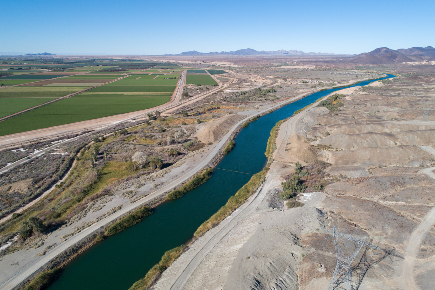
The All American Canal— approved for construction in 1928 as part of the Boulder Canyon Project, along with Hoover Dam that forms Lake Mead—is 80 miles long and makes agriculture possible in the Imperial Irrigation District (IID), the largest irrigation district in the U.S., with 3,000 miles of canals and drains located in Imperial County, California (see irrigation district #1 in the map below).
Only 3% of the water that reaches Imperial Valley through the All-American Canal is used for urban/rural and industrial consumption. The remaining 97% is pumped to irrigate 500,000 acres of agricultural land in the irrigation district (IID). All the excess water from farm runoff ends up in the Salton Sea, a lake 35 miles long and 15 miles wide.
The All-American Canal starts at the Imperial Dam, runs southwest to the U.S.-Mexico border and then west parallel to the border, serving irrigation districts along the way and supporting water transfers to an irrigation district in Mexico. The trajectory of the All-American Canal is shown below.
A point diverting water to the US-MX border: The Imperial Dam
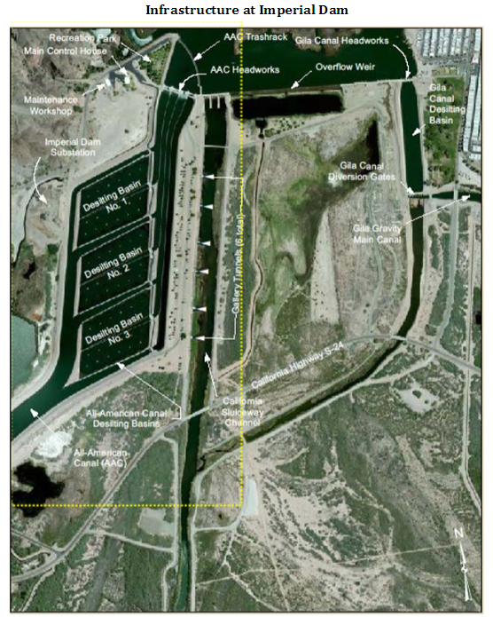
The All-American Canal starts at Imperial Dam (a diversion dam also built under the Boulder Canyon Project) where water is raised 25 ft above ground level and flows through desilting basins where sediments and salts are removed. Clear water is later diverted to the All-American Canal (see picture below). Sediments, salts and water are returned to the Colorado River through the California Sluiceway Channel. This water will eventually reach Mexican farmers at the border through transfers delivered to the Northern International Boundary (NIB) (or Límite Internacional Norte in Spanish), where the water is received by the section of Rio Colorado Irrigation District #014 located in Baja California (see irrigation district #5 on the map above).
Source: U.S. Bureau of Reclamation. Available here.
Agricultural Hub 2: Bard Water District on California border
Before reaching the Imperial Irrigation District (IID), the All-American Canal also makes agriculture possible to the east of IID in California and in Yuma, Arizona. Water from the canal leaves the desilting basins at Imperial Dam and is partially diverted through four turnouts in the canal (Reservation Main, Titsink, Yaqui and Pontiac turnouts) to supply water to agricultural land referred to as the Reservation Division in California. The Reservation Division is part of the Yuma Project of 1904, which was designed to bring water from the Colorado River to develop agricultural land in Yuma, Arizona. However, part of the Reservation Division is located in eastern Imperial County in California.
The Reservation Division is further split into the Bard Unit, where the Bard Water District is located. This unit, established in 1927, supplies water to 7,120 acres of private land for agricultural purposes. Since 1981, the operation and maintenance of the unit have been part of the water district (see irrigation district #2 in the map above).
Agricultural Hub 3: Indian Unit on California border
The Reservation Division also includes the Indian Unit that corresponds to 7,556 acres owned by individual Indian allotees from the Fort Yuma Reservation in California. The land is leased and administered by the Bureau of Indian Affairs, but since 1983 Bard Water District has been responsible for the operation and maintenance of the water delivery systems (see irrigation district #3 in the map above).
Agricultural Hub 4: Yuma County Water Users’ Association on Arizona border
The All-American Canal also makes agriculture possible for parts of Yuma County, Arizona, by connecting to the Yuma Main Canal (shown in the map above), which supplies additional water to the Reservation Division in California before reaching the Valley Division in Yuma, Arizona. The 3.5-mile canal was developed under the Yuma Project.
The Valley Division water facilities are owned by the U.S. and since 1951 have been operated by the Yuma County Water Users’ Association (YCWUA). The association delivers water to farmers for 53,450 irrigatable acres, as well as supplies drinking water to the City of Yuma and water to the West Cocopah Indian Reservation for 6,000 irrigatable acres. The association also operates a pumping facility, located at the Southerly International Boundary (or Lindero Internacional Sur in Spanish), which raises groundwater from drains in Yuma Valley and sends it to the Sanchez-Mejorada Canal in Mexico.
Links to Mexico
Water pumped by the irrigation district (YCWUA) is used to meet part of the U.S. commitment to transfer water from the Colorado River to Mexico under the 1944 Water Treaty. Water transfers go to Rio Colorado Irrigation District #014 in Sonora, Mexico.
Changes in water quality and other challenges have been addressed and entailed bilateral agreements and the building of additional water infrastructures to reduce the salinity of the water transferred due to agricultural runoff. We will explore this salinity topic in more detail in a future post.
The table below summarizes the irrigation districts where water from the All-American and the Yuma Canals is used for agriculture.
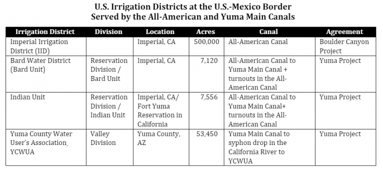
Source: Compiled by NADBank staff. Note: Information about the use of groundwater (aquifers) or other water sources is excluded.
What’s next?
In the next installment, we will look at another major infrastructure project that provides water to the U.S.-Mexico border through the Gila Gravity Canal, making agriculture possible on the Arizona border in Yuma County. We will also present the links and challenges between water conveyed through this canal and agriculture in another part of the Mexico border.
*The views expressed in the article belong solely to the author(s) and do not necessarily reflect the opinion or position of NADBank
Post Categories: Water