Making agriculture possible at the Arizona border: The Gila Gravity Canal
Colorado River Basin from the lens of the U.S.-Mexico Border (Pt.4)

Nota: El contenido de cada blog se publica en su idioma original para preservar la integridad de la voz del autor.
Water from the Colorado River has been a critical factor in developing the agriculture sector east of Yuma, Arizona, where many irrigation districts have been developed since the early 1900s. This post will talk about the role of the Gila Gravity Canal in creating farmland in eastern Yuma County, where five agricultural hubs irrigate approximately 98,000 acres of land— area about two-thirds the size of the city of Tijuana, Baja California.
One of the largest irrigation districts of the U.S.-Mexico border is the Wellton-Mohawk Irrigation and Drainage District (WMIDD), where wells were drilled to drain excess water from fields as the new irrigation system, combined with a shallow aquifer, quickly raised the water table, saturating the fields. Water from these wells with a high saline content was later discharged into the natural flow of the Colorado River. It would fulfill part of the 1944 Water Treaty allocation from the U.S. to Mexico. In the 1970s, the poor water quality created challenges for Mexican farmers.
This post will briefly explain how the Gila Gravity Canal conveys water from the Colorado River to farmland east of Yuma and discuss the related water quality challenges for the WMIDD.
General Overview of the Gila Gravity Canal
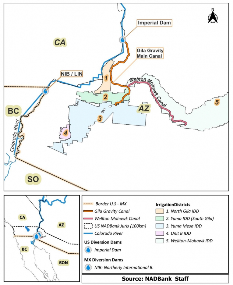
The Gila Project consists of infrastructure projects completed in 1957 to supply water east of Yuma. Starting at Imperial Dam as the All-American Canal, water flows from the eastern side of the dam through the Gila Canal Headworks (see map below) to the Gila desilting basin and then to the Gila Gravity Main Canal, which extends 20.5 miles to deliver water to five irrigation districts.
Gila Gravity Canal and Irrigation Districts
The Gila Project is divided into the Melton-Mohawk and the Yuma Mesa. The latter is further broken up into various units (see graph below).
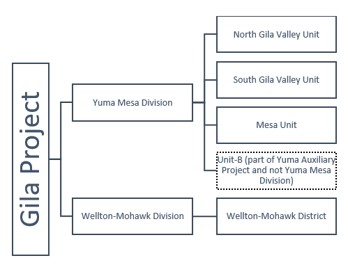
In each of these units, agriculture has flourished in the following irrigation districts:
Agricultural Hub 1: The North Gila Irrigation and Drainage District (NGVIDD)
Part of the Yuma Mesa Division of the Gila Project, this district is commonly referred to as the North Gila Valley Unit. A set of turnouts in the Gila Gravity Canal provides water to the Unit. NGVIDD has been operating the irrigation system since 1918, making it one of the oldest irrigation districts on the U.S.-Mexico border. The district provides water to 6,320 acres of farmland (irrigation district #1 in the map above).
Agricultural Hub 2: Yuma Irrigation District (YID)
YID belongs to the South Gila Valley Unit, which began operating in 1973 and serves around 800 acres of farmland. Water is delivered to the unit through turnouts in the Gila Gravity Canal (irrigation district #2 in the map above).
Agricultural Hub 3: The Yuma Mesa Irrigation and Drainage District (YMIDD)
This district is part of the Mesa Unit and has been supplying water to 25,000 acres of farmland and local municipalities since 1954 (irrigation district #3 in the map above). At the end of the Gila Gravity Canal, the Yuma Mesa Pumping Plant lifts water 52 ft to supply the Yuma Mesa distribution system and an adjacent irrigation district called Unit-B.
Agricultural Hub 4: Unit B Irrigation and Drainage District
Unit-B is not part of the Yuma Mesa Division nor the original Gila Project; it was built as part of the Yuma Auxiliary Project. That project entailed bringing water to 3,305 acres of farmland adjacent to the Yuma County Water Users’ Association (YCWUA), which receives water from the Yuma Canal diverted from the All-American Canal (see previous post). Nevertheless, changes have occurred over the years, and the irrigation district has received water from the Gila Project since 1960 instead of the All-American Canal.
Agricultural Hub 5: Wellton-Mohawk Irrigation and Drainage District (WMIDD)
Water is diverted from the Gila Gravity Main Canal to the Wellton-Mohawk Canal, which extends 18.5 miles to irrigate 62,750 acres of farmland. This irrigation, coupled with shallow aquifers, caused the water tables to rise. To control groundwater levels and remove salt (leach) from the soil, 90 drainage wells were drilled. Each well is 300 feet deep and spaced about one mile apart.
Conclusion
In summary, water from the Colorado River reaches irrigation districts on the Arizona border through two separate U.S. infrastructure projects. The following table summarizes the irrigation districts that receive water from the Gila Project.
Gila Gravity Canal and Irrigation Districts
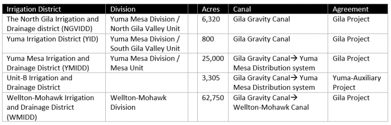
Note: Excludes information about underground (aquifers) or other water sources.
Source: Compiled by NADBank staff.
The next post on the Colorado River will address the salinity challenges of the water delivered by the U.S. to Mexico and the policy measures taken by the U.S. to address the problem.
Las opiniones expresadas en los artículos no reflejan necesariamente la opinión o posición de la institución.
Post Categories: Agua